
Enduro
Modifies the display of offline (vector) maps for use on off-road motorcycles with paths visually classified by "difficulty" linked to the type of machine and the details present in OpenStreetMap , allows routing calculations " all terrain" for 3 types of motorcycles (from the heaviest to the lightest).
(the installation process creates 3 new profiles with their configuration and guidance, the profiles and the existing Osmand configuration are not modified)
a video tutorial https://youtu.be/07nj4LoACdc

Notable Features:
-
Paths visually identified by roadability (colors) explanations (FR)
-
Useful/interesting POIs highlighted
-
Trail difficulty based on mountain biking and hiking tags explanations (FR)
-
Simplification for readability of mountain bike/hiking routes
-
Additional settings for readability while driving
-
How the style works
-
How routings work

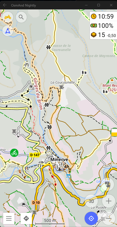
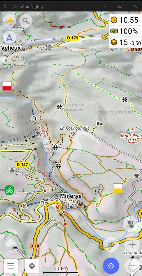
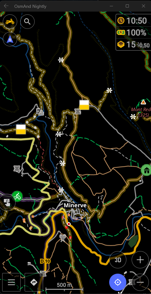
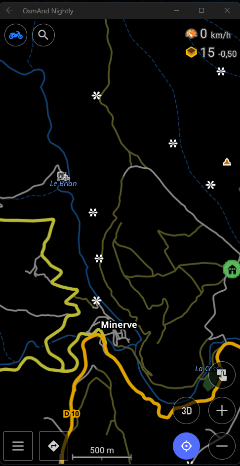
Screenshots

Instructions of installation
This file contains:
- 1 rendering
- 3 profiles (Enduro, Grand trail, Small trail)
- 3 routes (Enduro, Grand trail, Small trail)
First installation |
- Download file
- Open with OsmAnd
- Check all boxes to import all files
- Done!
Profiles with rendering + routing are predefined
|
Rendering update / Routing |
- Download file
- Open with OsmAnd
- Check only the "resources" boxes to import only the rendering and routing files
- Click on “Replace all”
- Done!
The new rendering and routings have replaced the old files
|

Documentation
operation
the display style is automatically applied to the 3 profiles created during-installation.
These 3 profiles are identical except for the color and routing assigned to them by the installation process.
these 3 profiles are necessary to use the 3 different routings provided.
- their options come from the style file and routing file assigned to them
- style options are grouped at the end of the "Configure map" in the submenu "Other card characteristics"
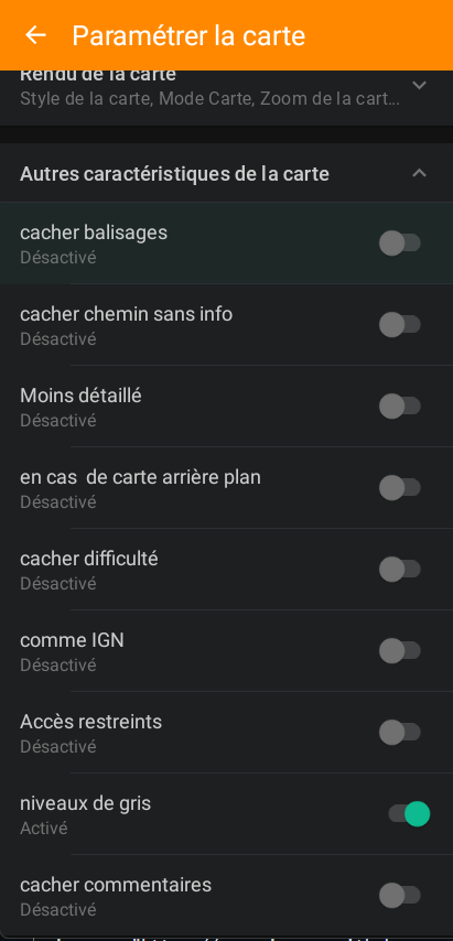
Options |
| hide markup |
removes the display of on-screen markup (highlight and icon) |
| hide path without info |
pass paths without OpenStreetMap details as solid lines |
| less detailed |
switch to road mode |
| in case of background card |
adds underline to paths to better see them over photos |
| hide difficulty |
hides the display of colored points on the map |
| like IGN |
allows you to align the representation of the paths with that of the IGN when maps are in the background |
| Restricted access |
disables the display of prohibitions and reserve/national park |
| grayscale |
alternative color scheme for ground cover |
| hide comment |
hides OpenStreetMap path comments on the map |
If the options appear "bulk" in the menu,
go to "Configure profile" > "User interface customization" > "Configure the map" and at the very bottom "Restore default settings" will allow you to find a tidy menu in which you can fold the subcategories.
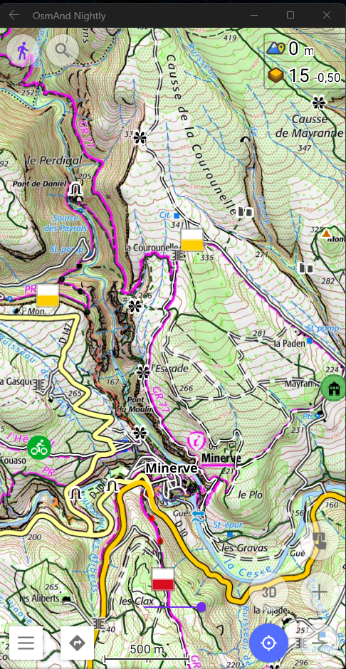
the style highlights the paths / trails as defined below
paths
trails
the paths are:
- in continuous green line if passable depending on the weather
- otherwise dotted green for the operating paths (field paths in common language)
- the stoned tracks suitable for vehicles are in brown continuous or dotted depending on their quality
- the trails are in dotted black
- a switch "hide path without info" in the style options allows you to switch the paths without details in OSM to solid lines, the tracks remain in brown and the trails in black.
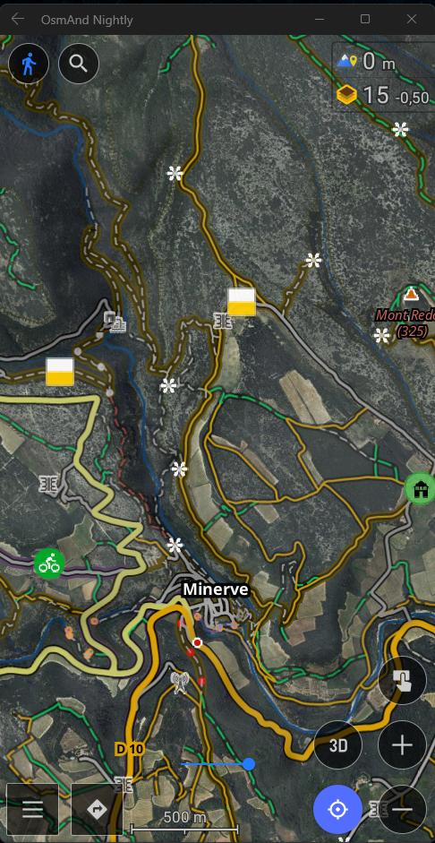
mode "like IGN"
in the 3 profiles it is possible to switch the display to a "like IGN" from the style options for
- on the one hand resemble IGN 1/25000 blue maps (better readability of certain elements at the expense of details on the paths)
- on the other hand allow the display in "under layer" IGN maps provided "live" or previously recorded without disturbing readability.
when using "like IGN" with maps in the background the following elements are disabled
- stream / river
- points on the ground except barriers
- texts except towns/villages
- level curves
element spawn levels are synchronized with map spawn levels.
"less-detailed mode"
for "road" (ideally in "night" mode)
- only tracks are shown in gray-green
- no markup
- fewer points (nature / soil etc)
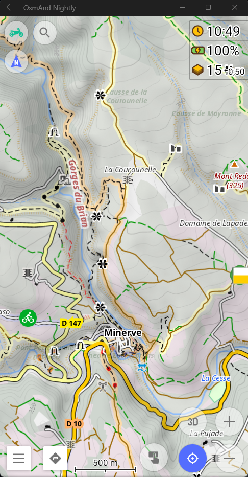
mode "in-case-of-background-card"
available in 3 profiles
- adds a "sublineage" darken the paths to make them more visible on satellite imagery
- toggles trails to light gray for readability
- colors suitable for various elements
(readability is improved for text by switching to night mode)
mode "night"
to save battery with an OLED screen and obtain a simplified contrast reading when driving.
- adapts the colors of various elements
- disables certain elements

Routing
Route calculation
Routing calculations for 3 types of motorcycle use, each of these routings calculates a route based on the information available in OpenStreetMap.
Explanations on the categories of tracks (FR)
Big trail
Only take you along the easy paths (the brown ones) and if none are found, by the road and very small bits of certain green paths.
- respect the prohibitions (paths in red on the map)
- respect the barriers (red dots on the map)
- "private" are managed as with the default profile. OsmAnd.
- the "forbidden" are grouped under the "no ban" in "Avoid the roads".
- 💡 there is another switch in "Avoid roads" to activate a "no paths" who avoids paths as much as possible by staying on the smallest roads possible.
- 💡 there is another switch in "Avoid roads" to activate a mode "if dry paths" which adds some "green" of the map in case there are no "brown" nearby.
⚠️ Beware of mud with unsuitable tires!
- considers all routes at the same level and therefore will trace as directly as possible.
- 💡 there are 2 other switches in "Avoid roads" to activate a "less road" and "even less road" which allow one or the other to find more paths if you make a journey of less than 200 km for the first and 100 km for the second.
⚠️ The calculation time is increased and the risk of app crashing too!
(put intermediate points to “force” the detour via the “good” paths if there are none in a direct line).
Small trail
will make you avoid paths and footways but will take all paths except those indicated "impassable"
- respect the prohibitions (paths in red on the map)
- respect the barriers (red dots on the map)
- "private" are managed as with the default profile. OsmAnd.
- the "forbidden" are grouped under the "no ban" in "Avoid the roads".
- discourages paths that are too difficult (you can place a crossing point on them to take them deliberately).
- authorizes passage on "easy" green dots on the map.
- considers all paths the same way (no passable or muddy)
💡 EXCEPT if the switch "sorts the paths" in "Avoid the roads" is active (checked) it will prioritize the paths from the most passable to unknown.
in fact it will penalize more and more the paths which are the least practicable
to go from point A to point B if 2 paths approximately equivalent in distance exist, the routing calculation engine will take the most passable one, the proportion of roads increases if the paths are not entered in OpenStreetMap.
- considers all routes at the same level and therefore will trace as directly as possible.
- 💡 there is another switch in "Avoid roads" to activate a "less road" which allows you to find more paths if you make a journey of less than 200 km.
⚠️ the calculation time is increased and so is the risk of the app crashing!
(do not put points too far apart to speed up the calculation - every 100 km for example)
Enduro
will take you everywhere except cycle paths and of course black spots (impassable ^^).
- all switches are inactive (everything is active, fords, frozen roads, private access, etc.)
- respect the prohibitions "no" and "private" EXCEPT if the switch "No prohibition" is active.
- respect absolute barriers (chain, gate, etc.)
- lower priority for the red dots on the map which will be avoided if alternative.
- consider footways as paths (many trails are wrongly marked footway)
- favor marked routes (hiking and mountain biking)
- slightly favor trails over paths.
- all roads are at the same level it traces the most direct.
(do not put points too far apart to speed up the calculation - every 100 km for example)
For me, a calculation between 2 points approximately 200 km apart takes 2 minutes.
Calculation
If you find the calculation too slow or you cannot calculate a route
- go to "configure profile"
- then "guidance parameters"
- "vehicle characteristics"
- "default speed"
and lower the max speed to 90 (or less if necessary)
know that the more you lower it, the faster the calculation but the more roads it takes.
(don't ban highways or tolls, they are already disabled)
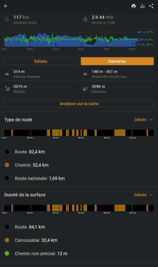
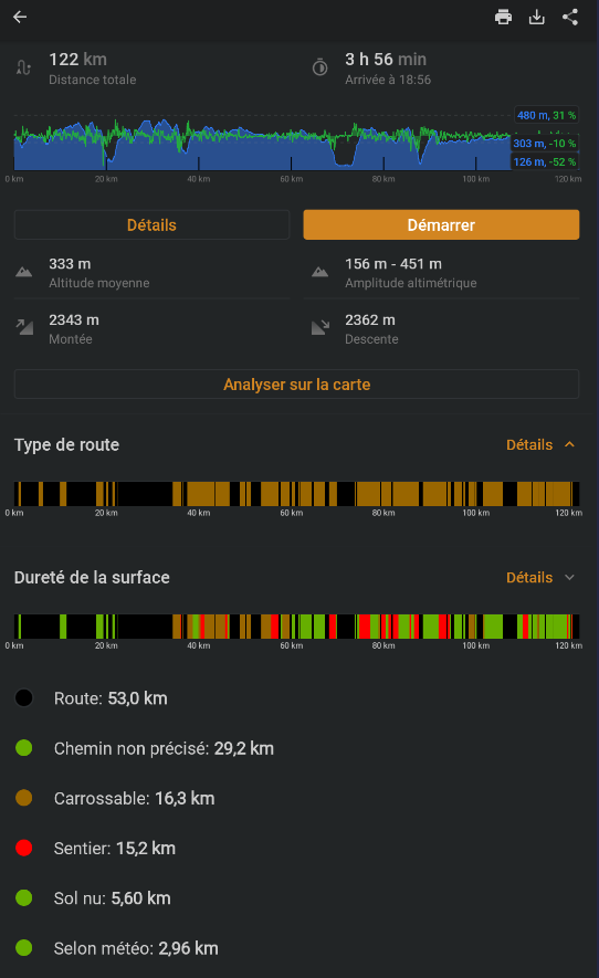
Examples
When you calculate a route you will have access to information about your route
road/path ratio (and trails for "enduro")
path type with colors matching those of the map with the style applied.
Here is an example in my region (south west) (around 100 km as the crow flies).
With "big trail" without active options:
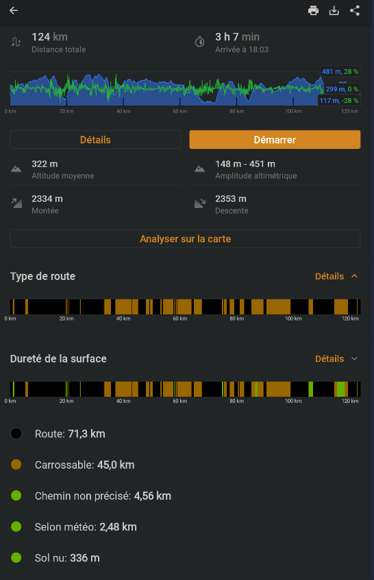
With "big trail" and the switch "if dry paths active:
which adds "green" less passable in a small proportion.
(note that the proportion of road decreases)
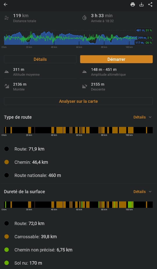
With the "petit_trail" and the switch "sort paths" active:
the results are often very close to the "gros_trail" with "if dry roads" active when paths are entered in OpenStreetMap.
(but the type of "green" paths changes by being less "passable")
in the case where the majority of paths are not specified, the "sort" paths impose more roads instead of "difficult" paths.
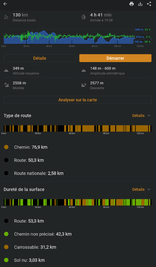
With the "petit_trail" without the switch "sort paths" active:
the proportion of roads continues to decrease, the paths not indicated in OpenStreetMap become more important, until they represent the majority of paths depending on the regions more or less indicated in osm.
The "enduro" with the trails in red.
Well... don't forget that it can be improved and that in the best of times
case it is based on the information added in OpenStreetMap which
may be obsolete (paths recently destroyed) or based on a
subjective impression of the person who provided it (difficulty level
mountain biking for example).
More details in routing

Legend
More details in the wiki
Tracks
| motorable tracks |
motorable tracks at night |
 |
 |
| motorable tracks IGN map |
motorable tracks IGN without map |
 |
 |
| less detailed motorable tracks |
less detailed motorable tracks night |
 |
 |
| rough motorable tracks |
rough motorable tracks night |
 |
 |
| dirt roads |
night dirt paths |
 |
 |
operating tracks
or without details |
night operating tracks |
 |
 |
| When the "hide path without info" option is activated in the "Details" menu of the style, the paths not specified in OSM are in solid lines. |
| forbidden tracks |
night operating tracks |
 |
 |
| The visualization of prohibitions in general is managed by the "restricted access" style option. |
Trails
| trail |
night trail |
 |
 |
| invisible path |
trail on photo |
 |
 |
| pedestrian |
night pedestrian |
 |
 |
| pedestrian with OK access |
pedestrian bridge |
 |
 |
| When the "restricted access" style option is active, walking paths are represented as paths. |
| cycleable |
cycle path with OK access |
 |
 |
| When the "restricted access" style option is active, cycle paths lose the red ban. |
Difficulty (for light motorcycles...)
Barrier
an icon depending on the type at close zooms and a red dot at far zooms
Balisages
| type GR |
type GR nuit |
 |
 |
| type GR loin |
type GR loin night |
 |
 |
| type GRP |
type GRP night |
 |
 |
| type PR |
type PR night |
 |
 |
| Mountain biking |
Mountain biking at night |
 |
 |
| road bike |
road bike night |
 |
 |
under Android, pressing the icon will open the route menu
Roads
| highway |
highway night |
 |
 |
| highway profile |
night highway profile |
 |
 |
| Main road (former national) |
Main road at night |
 |
 |
| Secondary route |
Secondary road at night |
 |
 |
| tertiary |
tertiary night |
 |
 |
| road/street |
road/street night |
 |
 |
| route pont |
road bridge night |
 |
 |
| route tunnel |
road tunnel night |
 |
 |
| route construction |
road construction night |
 |
 |
| gravel road |
dirt road |
 |
 |
Railways
| railways |
railway tracks night |
 |
 |
| disused railways |
disused railways night |
 |
 |
| railway bridge |
railway bridge night |
 |
 |
| tunnel railway |
tunnel railway night |
 |
 |
Notable elements
| village |
hamlet |
 |
 |
| isolated house |
isolated house at night |
 |
 |
| shelter |
night shelter |
 |
 |
| refuge |
ruin |
 |
 |
| career |
career night |
 |
 |
| cascade |
Power plant |
 |
 |
| fence |
OSM comment |
 |
 |
| cliff |
forest |
 |
 |
| caves |
cave night night |
 |
 |
| ford |
place called |
 |
 |
| electric line |
military |
 |
 |
| mine |
monument |
 |
 |
| parc national |
parc national nuit |
 |
 |
| national park |
national park night |
 |
 |
| pipeline |
radar |
 |
 |
| summit |
summit night |
 |
 |
| mountain pass |
mountain pass night |
 |
 |
| source |
potable water |
 |
 |
| gondola |
night gondola |
 |
 |
| point of view |
 |
the rest is easily identifiable and pressing the icon opens the details of the POI